


About
PSGIS is an innovative geospatial consulting company. We use Global Positioning Systems (GPS) and Geographic Information Systems (GIS) to create visual tools to find solutions to spatial and geographic challenges. Our services are useful to private corporations, nongovernmental organizations, and local, state, and federal governments. PSGIS are very familiar with the implementation of spatial technologies and we feel confident in our ability to transform your business challenges into solutions that contribute to your organization.
Projects
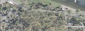
In 2009, Puget Sound GIS began working with the City of Seattle to design a database with over 200 miles of trail phenomena in 67 city parks. Our challenge was to create a baseline inventory with vector datasets. We began our project by surveying every liner foot of trail with GPS technology and gathering related field data to start our analysis. Through this process we would track and maintain new and existing layers within the City of Seattle GIS network. Overall, our duties include developing citywide trails databases, gathering updated field data, and modeling complex datasets with innovative GIS software. These objectives would help the City of Seattle evaluate various trail attributes, park features and analyze current site conditions and progress. Our capabilities included developing new feature attributes and template trail maps for Seattle Park and Recreation and the public domain.

Qualifications
Puget Sound GIS experience includes database creation, inventory mapping, data modeling, spatial analysis, application framework and interface development. Most importantly, we strive to help clients define geographic information and understand how spatial technologies can be successful when developing better strategic decisions for information access. We will work closely with you to understand your problems and questions.