Geographic Information Systems (GIS) and Global Positioning Systems (GPS) are useful tools for creating, storing, managing, and communicating spatial information. Puget Sound GIS uses these important analysis and communication tools for mapping, data analysis, modeling, and data storage.
We Specialize In:
- Geographic Information Systems Consulting
- Spatial Analysis
- 3D Modeling
- Scientific Research
- Database Migration Services
- Applications Development
- SQL Systems Integration
- Data Infrastructure Design and Implementation
- Site-specific response plans
- GPS Mapping
- Cloud Workflow Management
- Mobile Application Technology
GPS:
Puget Sound GIS uses GPS to complement our field work in trail feasibility studies, master plans, park plans, and in the implementation of these projects. Accurately recording site conditions and potential improvements significantly improves the quality of our data.
Advances in GPS technology allows us to correct outdated data and provide accurate location information. Changes to site characteristics can be edited in the field and updated into the GIS. Once all the corrections are finalized a variety of maps displaying various attributes can be designed and uploaded into web-application.
Mapping:
Maps can provide geographic information, illustrate spatial relationships, and visualize multi-dimensionally. Puget Sound GIS has extensive experience providing clear and concise maps to support a variety of user needs.
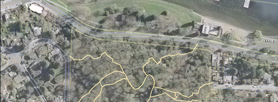
Mapping efforts helped the City of Seattle by providing baseline data on existing site conditions and created site specific maps that would be used for a variety of uses.
Master Plan Maps:
GIS-based master plan maps directly link data on existing or proposed improvements with spatial data. This provides a powerful tool for communication with the public.
User Maps:
GIS-based trail maps are seamlessly integrated with land use data.
Analysis Mapping:
Puget Sound GIS uses a number of GIS-based tools to help users see and understand complex data and help shape recommendations.
The 2010 City of Seattle Trail Inventory accomplished more than an evaluation; it provided spatial solutions to geographic relationships. The geodatabase created a visual tool that allowed management to analyze and visualize trail system data and as technology advances, we will continue to discover new ways to apply GIS to help make management and planning decisions.